
My NC500
1,357.9 miles. Thirteen days. Twelve nights. One grey Volkswagen campervan.
NIX NC500: VANILLA WENT NORTH AND I DROVE STRAIGHT INTO ANOTHER WORLD

1,357.9 miles. Thirteen days. Twelve nights. One grey Volkswagen campervan.
Picts. Vikings. Castles. Whisky. Highland cattle. German U-boats. Atlantic beaches. Tiny roads. Huge mountains. The Mermaid of the North. Applecross. Bealach na Bà.
And one magnificent day when I travelled precisely 0.8 miles.
I thought I was going to Scotland to drive the NC500.
That now seems a spectacular understatement.
The plan sounded beautifully simple. Load Vanilla. Leave Staffordshire. Reach Inverness. Drive around the top of Scotland. Take an irresponsible number of photographs. Fly the drone whenever the weather wasn't attempting to relocate it to Norway. Drive Bealach na Bà. Come home.
Easy.
Except when I later went back through the actual GPX trail, the journey became something much bigger.
The complete expedition covered 1,357.9 miles. The genuine Inverness-to-Inverness loop came out at 520.4 miles.
So technically mine was the NC520. I am not currently demanding Scotland replaces the signs. But I have the GPS.
More importantly, the route gave me the journey back. Not just the famous places, but the tiny moments between them. Fuel stops. Coffee. Drone flights. Beaches. Castles. Pubs. Sunsets. The places where I stopped because the view through Vanilla's windscreen was simply too good to drive past.
The NC500 stopped being a road. It became a time machine.
📸 VIEW THE COMPLETE NC500 PHOTO ALBUM
READY FOR THE OFF
Sunday 21 September 2025.
The first waypoint in the route says exactly what it should: Ready for the off!
Vanilla loaded. Cameras aboard. Drone aboard. Coffee infrastructure operational.
North.
Manchester. Skelmersdale. Cumbria. Shap. The border. Stirling. Pitlochry.
Then finally: NC500 START.
Inverness.
Hundreds of miles under Vanilla's wheels and the famous bit hadn't even started.
A sensible man would probably have stopped.
I carried on to Balintore.
Obviously.
BALINTORE: FIRST NIGHT, FIRST MERMAID
Then appears one of my favourite waypoints from the entire expedition.
Mermaid of the North.
Yes. I really did see her.
There she was sitting on the rocks at Balintore looking across the Moray Firth.
I'd left Staffordshire, reached the NC500 and almost immediately found a mermaid.
That's a strong opening chapter.
Behind the sea views sits something much older. Easter Ross is Pictish country, a landscape where people were leaving extraordinary carved art more than a thousand years before my Volkswagen arrived.
Sea. Mermaid. Picts. Campervan.
Night one had delivered.
MONDAY MORNING: TEA FIRST
The following morning my route records two important developments.
Monday sunrise.
First cuppa of the day.

Forget dramatic expedition photography for a moment.
This is the true fuel behind British exploration.
Tea.
GLENMORANGIE AND DUNROBIN
Then came Glenmorangie Distillery.
Sunrise. Tea. Whisky distillery.
Scotland had clearly assumed responsibility for itinerary planning.
A little farther north came Dunrobin Castle, all turrets, gardens and sea views. It looks as though somebody accidentally delivered a French château to the Highlands and everybody agreed not to mention it.
Beautiful place. Complicated history. Camera out.
THE HIGHLAND COO HAS ENTERED THE CHAT
Then came an essential Scottish road-trip milestone.
Highland cattle.

Look at that face.
That is an animal that has watched thousands of tourists pull over, take photographs and make jokes about its fringe.
It remains entirely unimpressed.
Quite right too.
JOHN O'GROATS: YES, OF COURSE I TOOK THE PHOTO
Eventually one of Britain's most famous place names appeared.
John o'Groats.
Vanilla had made it from Staffordshire to the far north-east of Scotland.
Yes, I know Dunnet Head is farther north. Somebody somewhere is already putting on a waterproof jacket to tell me.
That isn't the point.
John o'Groats is a road-trip moment. You arrive. You see the sign. You grin. You take the photograph.
THURSO: TENNENT'S, CURRY AND THE EDGE OF BRITAIN
Then came Thurso.
The route becomes wonderfully honest.
Thurso campsite.
First pint of Tennent's.
Last curry for a while.
That might be the finest three-line description of arriving in northern Scotland ever recorded.
TONGUE: NOW THE DRONE GOES UP
Then the daily mileage started collapsing.
And that was exactly when the NC500 really came alive.
I stopped asking, "How far am I going today?" and started asking, "What looks interesting next?"
Then came Tongue and the Kyle of Tongue.
This is why I carry a drone.
From ground level, the Kyle is beautiful.
From above, the whole geography opens up.
Water. Mountains. Roads. Tiny buildings. Vanilla reduced to a little grey speck in an enormous Highland painting.
HIGHLAND CHICKEN: SERIOUS CULTURAL RESEARCH
Then came dinner.
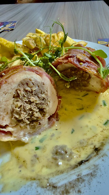
Chicken. Bacon. Whisky and peppercorn sauce.
Now we're travelling.
I appreciate castles. I appreciate geology. I appreciate centuries of Scottish history.
But there comes a point after staring at mountains all day when civilisation's greatest achievement becomes putting whisky sauce on chicken.
LOCH ERIBOLL: THE WATER HAS SEEN THINGS
Then came Loch Eriboll.

Look at it.
Quiet. Vast. Almost impossibly peaceful.
Then add the history.
Norse fleets knew these northern waters centuries ago. At the end of the Second World War, German U-boats surrendered here.
Viking ships. German submarines. Same Highland water.
That's when history changes photography.
DURNESS: THE WORLD GETS BIGGER
Then Durness.
Now northwest Scotland had properly taken control.
Atlantic. Cliffs. Huge skies. Pale sand. Water that looks suspiciously tropical.
And then Sango Sands.

This photograph explains why my mileage was becoming ridiculous.
Why would I rush away from that?
My Tongue-to-Durness day came to just 24.4 miles.
At work, twenty-four miles barely gets the HGV seat warm.
Here it could fill an entire day.
SANGOBEG: THE EDGE OF EVERYTHING

Sand. Atlantic. Moorland. Almost nothing else.
Which was precisely why I loved it.
No rush. No traffic. No timetable. No reason to be anywhere else.
SMOO CAVE: SCOTLAND OPENS A HOLE IN ITSELF
Then came Smoo Cave.
And this wasn't somewhere I vaguely passed near. The route puts me there.
A huge opening cut into the coastline by the combined work of sea and freshwater.
Dark. Wet. Echoing. Massive.
The sort of place where geology stops being something from a school textbook and starts looming over your head.
After that came another wonderfully honest waypoint: The closest I can get to Cape Wrath.
SCOURIE: THIS IS WHY I OWN A CAMPERVAN
Then Scourie.
And this photograph pretty much explains the entire point of Vanilla.

Indium Grey. Highland coast. Home for the night.
Drive somewhere extraordinary.
Stop.
Open the door.
Make tea.
Stay.
No reception desk. No room key. No checkout time.
Home has moved with me.
SCOURIE FROM ABOVE

This is where drone photography earns its place in the kit.
From the ground, the landscape surrounds me.
From the air, I understand how it fits together.
KYLESKU AND THE B869
Then Kylesku.
Today the bridge makes the crossing effortless. But it only opened in 1984.
I remember 1984.
Before the bridge, vehicles crossed by ferry.
Then came the B869.
Single track. Passing place. Corner. Climb. Drop. Rock. Sea. Another corner.
Then what appears to be a spare corner Scotland had ordered and couldn't return.
This is exactly where Vanilla makes perfect sense.
B869: DONE.
ACHMELVICH: ARE WE ABSOLUTELY SURE THIS IS SCOTLAND?

White sand. Clear turquoise water. Highland rock.
Apparently Scotland has been hiding Caribbean-looking beaches behind weather forecasts involving horizontal rain.
Underneath it all sits geology of almost incomprehensible age.
Parking a 2022 Volkswagen beside rocks measured in billions of years does rather destroy the phrase "latest model".
ARDVRECK CASTLE AND ULLAPOOL
Then came Ardvreck Castle beside Loch Assynt.
The sort of place where I tell myself I'll take two photographs and be back at Vanilla in ten minutes.
An hour later...
Then Ullapool.
And possibly my favourite statistic from the entire trip.
One day there produced:
0.8 miles.
POINT EIGHT.
I had started with a 431-mile monster.
Now I was travelling less than one mile in a day.
Progress.
I had finally mastered advanced campervan technique.
Parking.
WESTER ROSS AND TORRIDON
Eventually Vanilla moved again.
Gruinard. Gairloch. Loch Maree.
And Wester Ross started behaving outrageously.
The problem wasn't finding something to photograph.
The problem was driving five miles without finding something else to photograph.
Then Torridon happened.
Good grief.
Huge mountains. Dark water. Cloud clinging to summits. Roads reduced to tiny scratches through the landscape.
I'm standing there with modern cameras, a modern drone and a 2022 campervan.
And the mountains essentially say:
That's nice.
APPLECROSS: THE SANCTUARY
Then Applecross.
War memorial. Applecross Inn. The Walled Garden. Campsite.
I didn't simply flash through.
I stayed.
And beneath the modern road-trip legend sits something far older.
In AD 673, Maelrubha established an important Christian community here.
A'Chomraich. The Sanctuary.
BEALACH NA BÀ: THE ROAD I'D BEEN WAITING FOR
Then came 1 October.
Applecross behind me.
Mountain ahead.
Bealach na Bà.
The Pass of the Cattle.
Long before campervans, motorcycles and road-trip videos, people were moving cattle through these mountains.
Today it's hairpins, steep gradients, single track, passing places and absolutely enormous views.
Vanilla was brilliant.
Corner. Climb. Hairpin. Passing place. Another climb. Another view. Another completely unnecessary grin.
B869: YES.
BEALACH NA BÀ: VERY YES.
EILEAN DONAN AND FULL CIRCLE
Then my GPX records something wonderfully precise.
Looking at Skye.
That's what happened. I looked towards it. I didn't invent an imaginary tour of Skye years later.
Then Eilean Donan Castle.
One of those Scottish places I'd seen in photographs, calendars and films for years.
Then suddenly it wasn't somebody else's photograph.
It was outside Vanilla's windscreen.
Then Inverness Castle.
Back where the loop began.
520.4 miles around the actual NC500.
Loop closed.
AND I STILL WASN'T FINISHED
From Inverness I continued south.
Loch Ness.
Fort Augustus.
Bridge of Oich.
Ballachulish.
Glencoe.
Loch Lomond.
Even the journey home refused to become boring.
HOME
Then eventually:
Arrived home.
3 October 2025.
1,357.9 miles.
Thirteen days.
Twelve nights.
And an awful lot more than a 500-mile road.
THE NIX NC500 SCOREBOARD
Total expedition: 1,357.9 miles
Actual NC500 loop: 520.4 miles
Total adventure: 13 days / 12 nights
Direction: Anti-clockwise
Biggest overall day: 431.1 miles
Biggest proper NC500 day: 107.4 miles
Shortest proper travelling day: 24.4 miles
Ullapool reset: 0.8 miles
Mermaid of the North: SAW HER
Kyle of Tongue: DRONED IT
Smoo Cave: YES
B869: YES
Achmelvich: VERY YES
Ullapool: TWO NIGHTS
Torridon: RIDICULOUS
Applecross: YES
Bealach na Bà: VERY YES
Vanilla: ABSOLUTE STAR
WHAT THE NC500 TAUGHT ME
Slow down.
That's it.
There will always be somebody online who announces they completed the NC500 in three days, climbed two Munros before breakfast, changed a gearbox at lunchtime and cooked a roast dinner in a lay-by.
Excellent.
Good for them.
I don't want that trip.
I want the 24-mile day.
I want the five-minute photo stop that becomes an hour.
I want coffee beside a beach.
I want two nights in Ullapool.
I want 0.8 miles.
Sometimes barely moving means you've finally found somewhere worth not leaving.
AND VANILLA?
This trip explains exactly why I love her.
She's not simply transport.
She's the expedition base.
Small enough for the B869.
Small enough for Bealach na Bà.
Big enough to sleep in.
Room for cameras. Room for drones. Room for food. Room for tea.
Wake up.
Open the door.
Scotland.
Very difficult to improve upon.
THE FINAL NIX VERDICT
I left Staffordshire thinking I was going north to drive a famous road.
What I actually found was an enormous outdoor museum with spectacular parking.
I saw the Mermaid of the North. I photographed Highland cattle. I stood at John o'Groats. I flew the drone above the Kyle of Tongue and Scourie. I looked across Loch Eriboll knowing the extraordinary history behind those waters. I stood at Sango Sands. I explored Smoo Cave. I drove the B869. I photographed Achmelvich. I stopped at Ardvreck Castle. I spent two nights in Ullapool. I crossed Wester Ross. I reached Applecross. I drove the Pass of the Cattle. I looked towards Skye. I saw Eilean Donan. I travelled through Glencoe.
And Vanilla carried me through every glorious mile of it.
NIX.
VANILLA.
SCOTLAND.
1,357.9 miles.
Thirteen days.
Twelve nights.
One unforgettable expedition, with the route and photographs to prove every glorious bit of it.


